Summary of the COSTS to UF of donating the right-of-way
by Natural Area Advisory Committee (19 March 2003)

On February 20, 2003, at a meeting of the Metropolitan Transportation Planning Organization, Ed Poppell, Vice-President of Finance and Administration, announced that UF would take the necessary steps to donate right-of-way for a four-lane extension of SW 24th Avenue from SW 34th Street to Archer Road. The land to be donated is part of UF's Natural Area Teaching Laboratory (NATL), which occupies 46 acres in the southwest corner of the UF campus. The road will require a 90-foot strip along NATL south border as shown in Fig. 1.

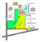
Fig. 1. Map of NATL showing the right-of-way of the proposed extension of SW 24th Avenue. (Click on thumbnail for a larger, annotated map.)

The Natural Area Advisory Committee is charged with recommending how NATL should be managed. Since 1994 it has worked to implement NATL's mission of teaching students and the public about ecology and biotic diversity. In this effort UF Administration has funded every improvement project that the Committee has proposed, for a total investment of more than $100,000. Nonetheless, the Committee was not consulted about the effects the proposed donation would have on NATL. Until UF administrators schedule a public hearing on the proposed donation, the Natural Area Advisory Committee must rely on this web site to describe its assessment of the costs to the University of making the donation. These costs are categorized below as environmental, academic, and community.

Environmental Costs
Richest portion of a preservation area will be destroyed
The road right-of-way to be donated is part of Preservation Area 1 in UF's Comprehensive Master Plan. Preservation Area 1 (all of which is within NATL) is UF's largest and best-protected remaining area of natural woodlands, which is the principal reason why, in 1993, a group of faculty proposed that it be developed as "a campus natural area and outdoor teaching laboratory." The proposed right-of-way is along the area's southern edge, which has the most uniformly favorable moisture conditions and hence has the most diverse flora and fauna including the largest, finest trees. A survey of trees within the road right-of-way is in progress and has already tallied more than 34 trees with trunk diameters of 18 inches or more (Fig. 2). For further insight into the uniqueness of the area, see the account by botanists Kitajima, Putz, and Judd.

Fig. 2. The largest (29 inches DBH) of at least 10 hickories with trunk diameters of 22 inches or more that would be bulldozed to clear the road right-of-way. Numerous large trees of other species are also in the right-of-way (e.g., live oaks, max. 29 inches; longleaf pines, max 24 inches; and sweet gums, max. 29 inches, if you omit a 42-inch giant that reduces to 27 inches at 7 ft up).

Wildlife habitat will be fragmented
As shown in Fig. 3, the proposed road will isolate the main body of upland forests in NATL from other wildlife habitat with which it currently connects. Of particular importance is that the road will isolate NATL's 1.6-acre southeastward extension from the rest of NATL. This extension, which contains NATL's Sinkhole Pond, currently serves as a protected corridor for wildlife to travel between Preservation Areas 1 and 2.

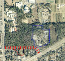
Fig. 3. Aerial photograph of NATL and adjacent wildlife habitat. Click on the thumbnail for a larger picture that shows how the road will eliminate 3.1 acres of the current 47 acres of protected wildlife habitat and leave fragments of approximately 28 acres (main NATL), 12 acres (P2 and Sinkhole Pond area), and 3.5 acres (a sink and two retention ponds).

For a fuller description of the effects of fragmentation and examples of the wildlife that will be affected, see Doug Levey's account and "Plants and Animals."

The road will pave over a recharge area
Most of the proposed roadway is through a basin (Fig. 4) that has no surface outlet. The paved roadways and sidewalks of the extension will significantly reduce the area where storm water now collects and eventually seeps into the ground. For a fuller understanding of the water quantity and quality issues of the extension, see Mark Clark's account.

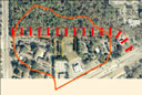
Fig. 4. A sinkhole just east of Regency Oaks Apartments is the lowest point in the karst basin outlined in orange. After even minor storms it overflows onto the right-of-way of the proposed extension. (Click on the thumbnail for more information.)


Academic Costs
The proposed road will degrade a valuable and irreplaceable academic facility. Whereas courses in physics and chemistry need conveniently accessible indoor laboratories, courses in the environmental sciences need natural areas that are conveniently accessible and secure. NATL has provided such space for ten years and has been well used, as illustrated by a list of representative projects recently compiled by the Natural Area Advisory Committee. Most of these projects would have been reduced in value and some would have been impossible had the proposed four-lane extension of 24th Avenue been in place.

For management purposes the Natural Area Advisory Committee decided that the northern half of NATL should be open to the public and K-12 groups visiting the Florida Museum of Natural History to help them learn about the ecosystems of north-central Florida. Many UF academic uses of NATL are compatible with public uses, but many others require that equipment and markers be left in the field or that wildlife be observed without frequent interruption. Thus the public is excluded from NATL's "academic area," which consists of 13 acres of hammock and 9 acres of upland pine (Fig. 5). The academic area is the part of NATL that is most severely impacted by the proposed road.

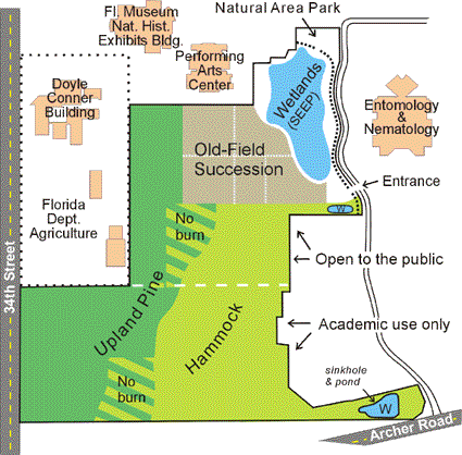
Fig. 5. Map of NATL showing its principal ecosystems and the division between public and academic areas.

NATL's academic area will be reduced
The proposed right-of-way will consume 3.1 acres (90 x 1500 ft.) of NATL's 22-acre academic area.

NATL's academic area will be fragmented
The Sinkhole Pond area of 1.6 acres will be cut off from the main body of NATL by four lanes of traffic. The easily accessible academic area is thus reduced by a total of 4.7 acres (3.1+1.6) which is 21% of the current 22 acres.

NATL's academic area will be degraded
As documented above under Environmental Costs, the damage that the road will inflict on NATL's plant and animal diversity will be out of proportion to the area lost. Construction of the road will directly eliminate plant and animal species found nowhere else in NATL, and other species will be lost because NATL's reduced and fragmented area will no longer be sufficient to maintain them.

The road will degrade NATL's academic functions in a variety of ways in addition to the reduction of its area and biotic diversity. For example, a four-lane roadway on the south edge of NATL will bring more noise, litter, and trespassers into the remaining academic area. Those who monitor birds and crickets by their calls will have difficulty hearing their subjects. More wildlife will be turned into roadkill, and prescribed burns, required to restore and maintain the upland pine, will become more difficult.

Community Costs
University community
Donation of a critical portion of a UF Preservation Area and of a valued academic facility is not a decision that can be made by fiat. It will ultimately require amending UF's Comprehensive Master Plan. UF's Land Use and Facilities Planning Committee must hold hearings and make recommendations on any amendments that the Administration proposes. If the Administration chooses to continue to pursue the donation, it should schedule public hearings on the issues involved before the end of this Semester. Otherwise the Administration will only create unnecessary turmoil among the faculty, students, and alumni who value NATL and do not understand UF's decision to diminish its area and quality without asking for their input.

Gainesville and Alachua County
UF's promise to donate the right-of-way for a four-lane extension of SW 24th Avenue led the MTPO to amend its Long Range Transportation Plan. Now Alachua County is on the verge of abandoning a well-vetted plan to construct a two-lane, divided 24th Avenue west of SW 34th Street in favor of a more expensive plan that has gone through no normal planning process and has the potential of making traffic worse rather than better (Fig. 6).

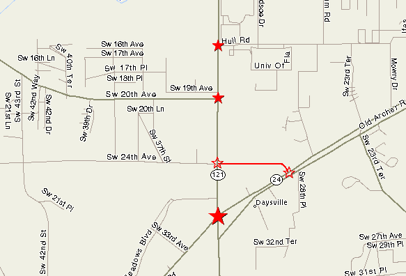
Fig. 6. Map showing the new intersections that the proposed extension of SW 24th Avenue will add to Archer Road and SW 34th Street. Intersections with traffic lights interrupt traffic flow. The new intersections are within the parts of these six-lane roadways that during rush hours are currently stop, wait, and creep.

Whatever the traffic effects of a four-lane 24th Avenue may be, its effect on potential commercial development in the area is clear: it will facilitate a more than doubling of the commercial development between Archer Road and SW 20th Avenue (Fig. 7).

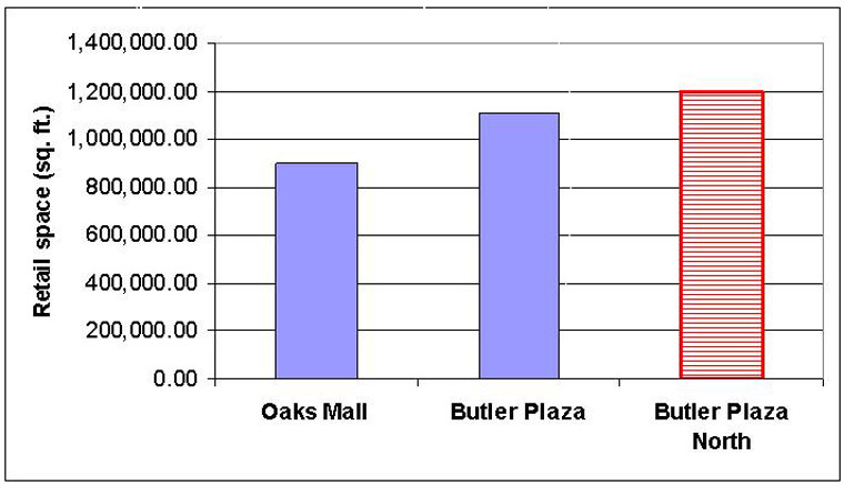
Fig. 7. The change from a two-lane to a four-lane SW 24th Avenue has been promoted as needed for additional commercial development in the area north of the eastern portion of Butler Plaza. As proposed, Butler Plaza North will have more retail space than the current Butler Plaza (the retail development north of Archer Road from SW 34th Street to I-75), which in turn has more retail space than Oaks Mall.

UF will not gain good will in Gainesville and Alachua County if it leads the County to invest scarce transportation dollars in a direction that soon or eventually proves to make matters worse or if it reneges on its commitment to donate the right-of-way only after significant dollars have been spent in the assumption that the commitment will be consummated.


If you find anything in the above that you judge to be inaccurate or misleading, please send the details to natl@ufl.edu so that corrections can be made.