| UF Academic Use | Public Use | Family Fun and K-12 Education |

Post-WWII history of NATL
Interview with George Freeman and Garry Lockerman, 23 June 1999
From 1950 until 1982, when he retired as IFAS Director of Facilities Operations, George Freeman supervised the University of Florida Experiment Station Farm, a part of which became NATL in 1994. In 1970, Garry Lockerman was hired to assist Freeman and continued to help manage farm operations until 2000.
This account, written by T. J. Walker, is based on a tape recording of the interview.
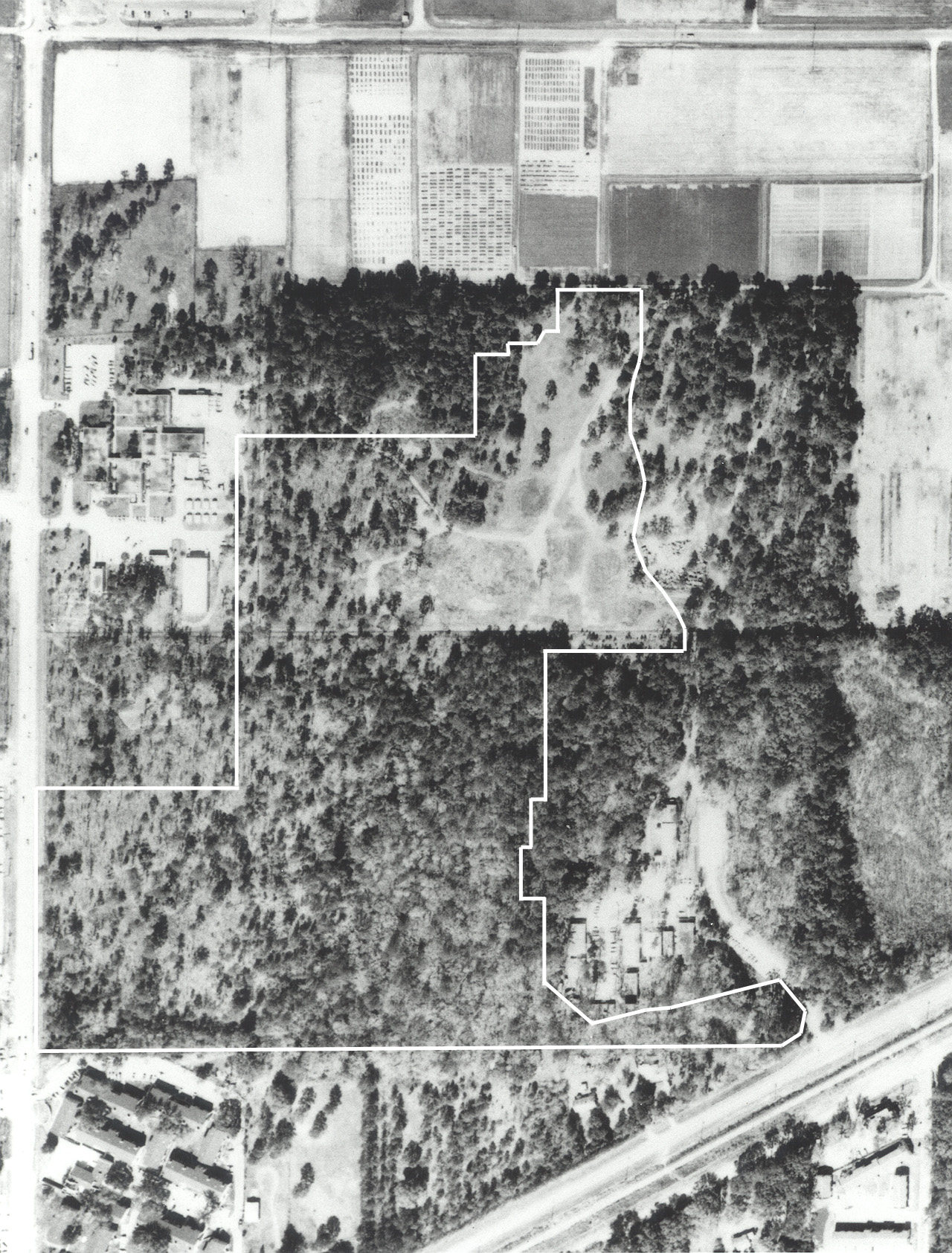
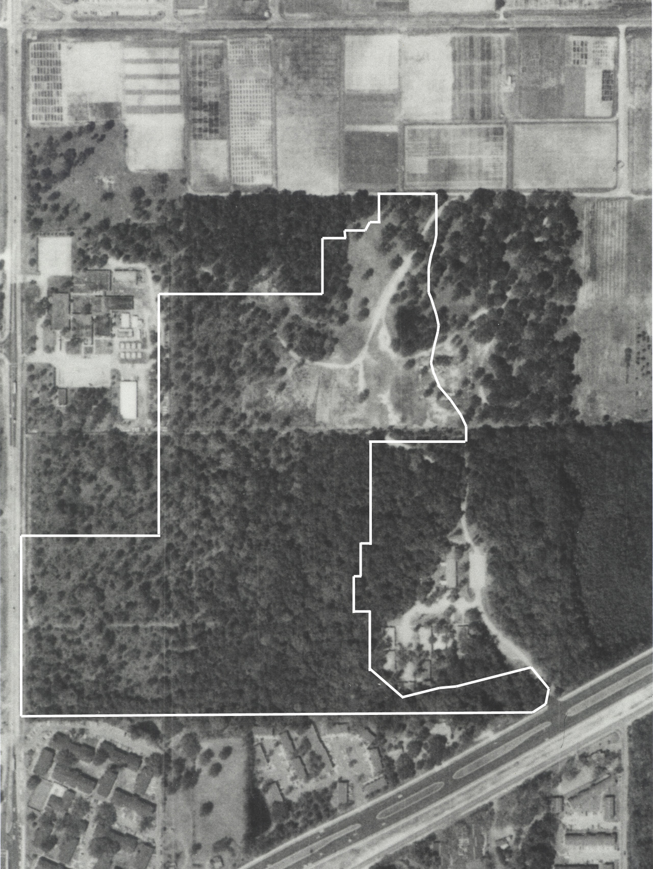
George, Garry, and I drove about the north part of NATL and then looked at a series of aerial photographs showing the area that is now NATL from 1937 until 1996. Most of the photographs were from the Soil Conservation series in UF's Image Library. The 1965 and 1996 photographs were from UF's Physical Plant Division.
George Freeman was a third-year student at UF when WWII began. He served in the Air Force for 5 years, returned to UF, got degrees in 1946 and 1948, and worked for International Harvester for 2 years before returning to UF to work on Bill Fifield's staff in Rolfs Hall (1). When Garry Lockerman joined Facilities Operations staff in 1970, George was its head. Neither George nor Garry knew any details of the State of Florida's 1944 purchase of the tract that includes NATL (2).
 |
On the 1949 photo (left), George pointed out the house and barn of Tom Adams, who was field foreman for Agronomy and who owned and farmed the land that is south of NATL and north of Archer Road. George noted that the square fenced area a little south of Hull Road and next to 34th Street was a burial ground for radioactive materials (3). George said that the straight road south of the burial ground was used by personnel coming to work on the Experiment Station Farm. Garry Lockerman pointed out that when he joined the Station staff in 1970 the entire farm area was gated. Gates at four entry points were closed and locked except from 7am to 5pm on weekdays. Note: The approximate current boundaries of NATL are superimposed (in white) on this and subsequent aerial photographs. |
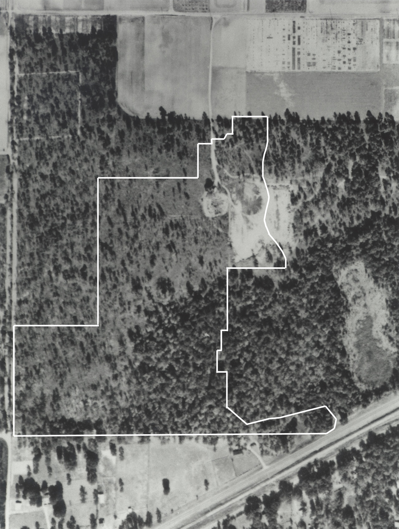 |
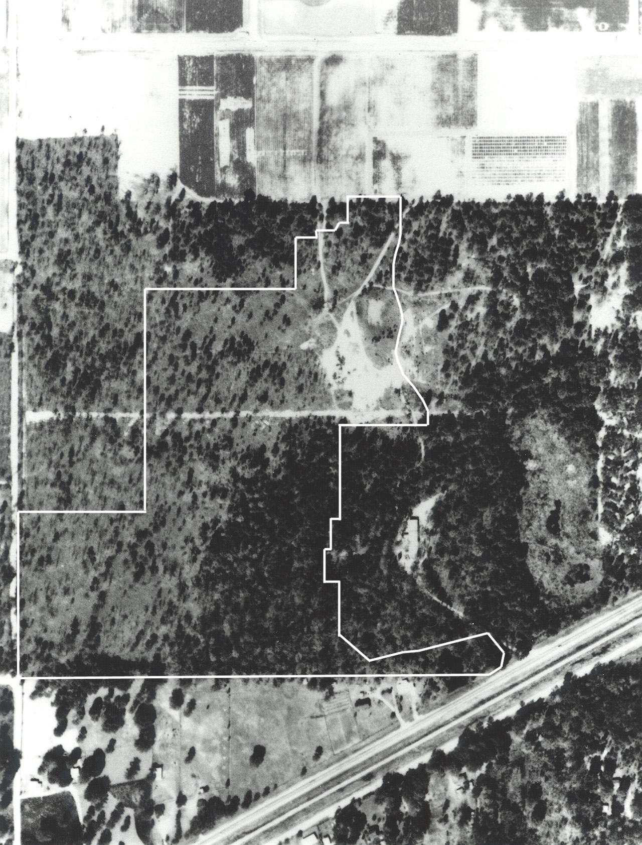
On the 1956 photo (left), a large bare area is where clay from the construction of the Medical Science Building had been dumped. When asked how the clay was distributed, George said that they just put it anywhere they could find a spot (4) and that they didn't have a very good bulldozer (5). A circular area at the south end of the road into the dumping site is a sinkhole (6). George said that when the tung grove on the north side of Hull Road was removed, the pulled trees were dragged by a tractor to this sink and burned (7). The sink was later used to burn all sorts of materials, including wooden building debris and field debris from Agronomy test plots (8). The harvested grasses were brought to the NATL area for processing and later burning, which accounts for the establishment there of exotic grasses, such as elephant grass and cogan grass. (George said the tung-burning sink was originally about 25 ft deep and that it was later filled in.) Eventually someone reputedly dumped pesticides in the sink, which resulted in EPA installing monitoring wells in and around the sink. The wells were pulled just prior to the re-contouring of the retention basin for the Stormwater Ecological Enhancement Project (SEEP). The east-most dirt trace along 34th Street is on NATL and may be where a sewer line was buried (9). |
 |
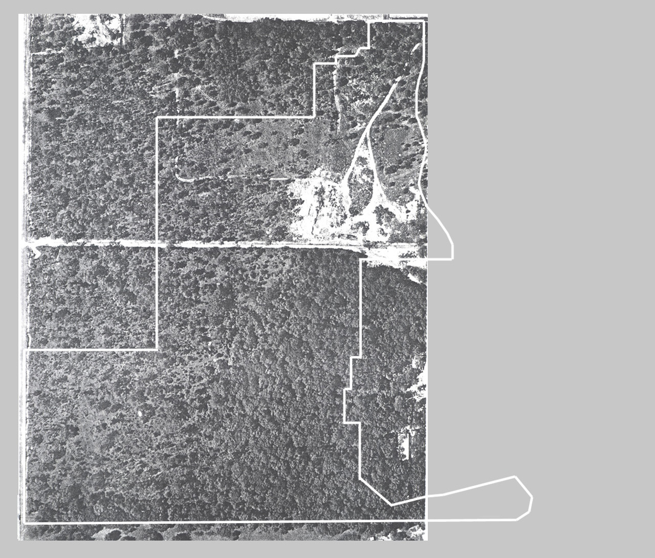
On the 1961 photo (left) what will become NATL's Main
Trail is evident. George said it was built from the east as access road
into the woods, where large limbs and the like could be dumped. A
triangular piece of the clay-dumping area is evident south of the Main
Trail (10). Garry identified a rectangular pale area [near grid point I2]
as a natural low area that had water and cattails during wet periods and
as the area where George "got stuck that day". George agreed and thought
it might have been a shallow sink. The first buildings in the Surge Area
are evident. George said they housed personnel from Veterinary Science
during the construction of the first building in the Vet Science complex.
The Surge Area was established by "presidential decision" and conflict
with the Farm was avoided by making its entrance from Archer Road. George
noted that Experiment Station Director John Sites was concerned that UF
might encroach on the Experiment Station's farm. In one case he directed
George to build a fence as quickly as possible to lay claim to all the
area north of Division Trail [gridline 8]. George built a fence along this
line and further fenced off the Surge Area by putting a fence along what
is now the south line of the Entomology/Nematology area west to the
western extreme of the Surge Area and then south to the south UF property
line. |
 |
|
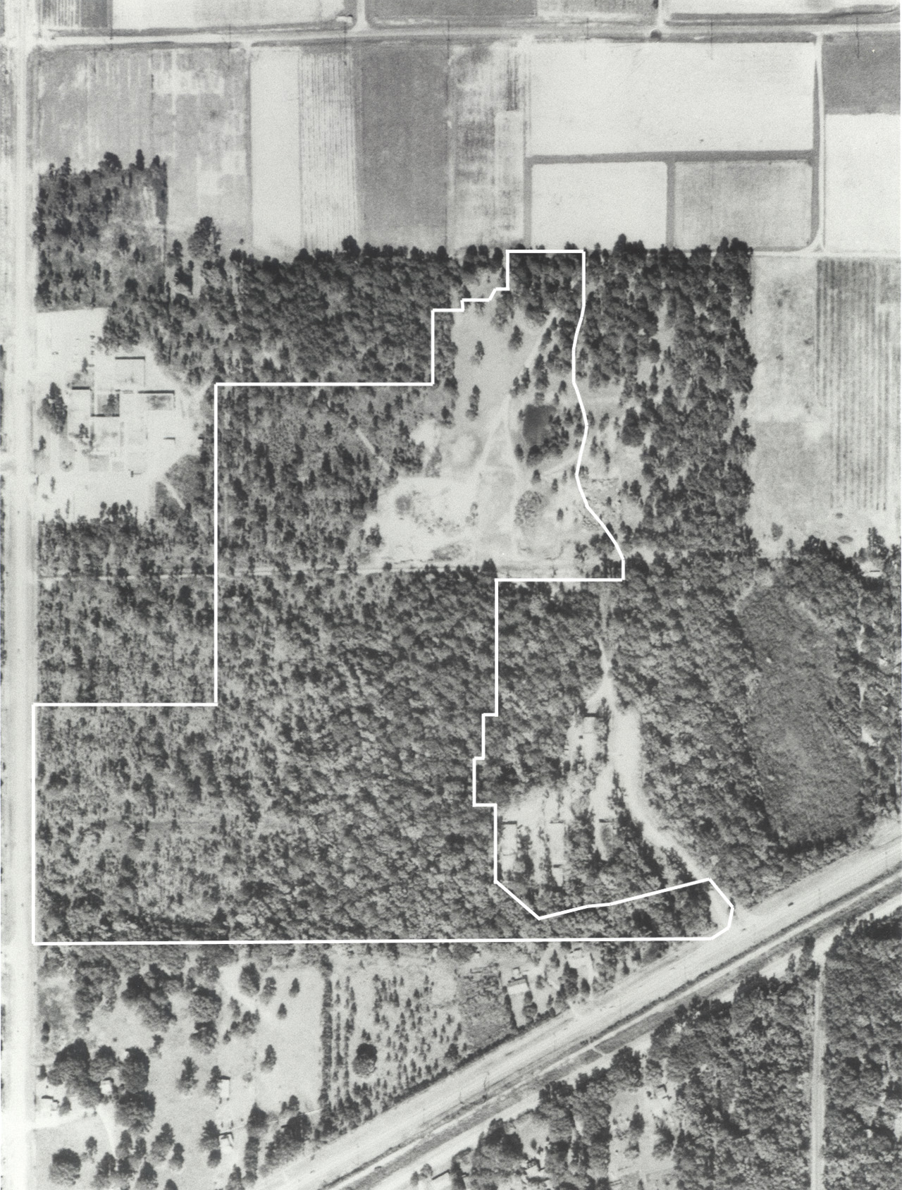 |
By 1965 [PPD aerial photo; above, left] and 1968 [Soil
Conservation series; left] the south portion of the soil dumping area has been
enlarged to the west [from gridline H past gridline G]. George offered no
particular reason for the expansion except that soil was being added and
taken from the site depending on the University's need to dispose of or to
acquire soil. An IFAS salvage yard had been initiated just east of what is
now NATL's east gate. In the 1968 photo, the initial buildings of the Division of Plant Industry complex on SW 34th Street are visible. |
 |
In the 1974 photo (left) the south lobe of the soil
dumping area extends to gridline F. This extension was occasioned by clay
from the construction of the Dental Science Building. Garry said that the
area now in the F4 grid square was used to stockpile good fill dirt that
was later used elsewhere and that the depth of fill there should be 4 to 5
feet and consist of a variety of layers including the Dental Science clay.
About this time, a golf-driving opportunity was created by making a raised
mound just southwest of grid point I5 (11). From this mound, golf balls
could be lofted onto a 200 meter fairway of occasionally mowed Bahia grass
to the north. The University golf team and others practiced here and the
place became known informally as "Freeman's driving range." An isolated
pine on the west edge of the fairway is conspicuous in the 1968 and
subsequent photos. George called it "the lonesome
pine." |
 |
In the 1979 photo (left), the utility right-of-way that
is now Gasline Trail is evident for the first time. Its visibility may
result from a new burial rather than the first burial of the four lines
that go along it (12). George thought that Gainesville Gas's gas line was
first to be put in and said that Calvin Green (PPD director) and Kim
Pofahl (Gainesville Utilities) put it in "surreptitiously" without an
easement being granted. (Earlier George had told me they did it while he
was away.) George pointed out that Calvin thought that since the Farm was
part of the University he could do what he wanted without asking
permission. A north-south row of red cedars, planted by Louis Neyland, can
be seen just east of the DPI compound. Neyland also planted slash pines,
in east-west rows (13). Both species were planted to grow fence posts for
the farm. Some of the cedars were later topped for Christmas trees. Garry
identified an area near grid point F3 that was used as a major area for
burning debris after the sink in which the tung trees were burned was no
longer used (14). |
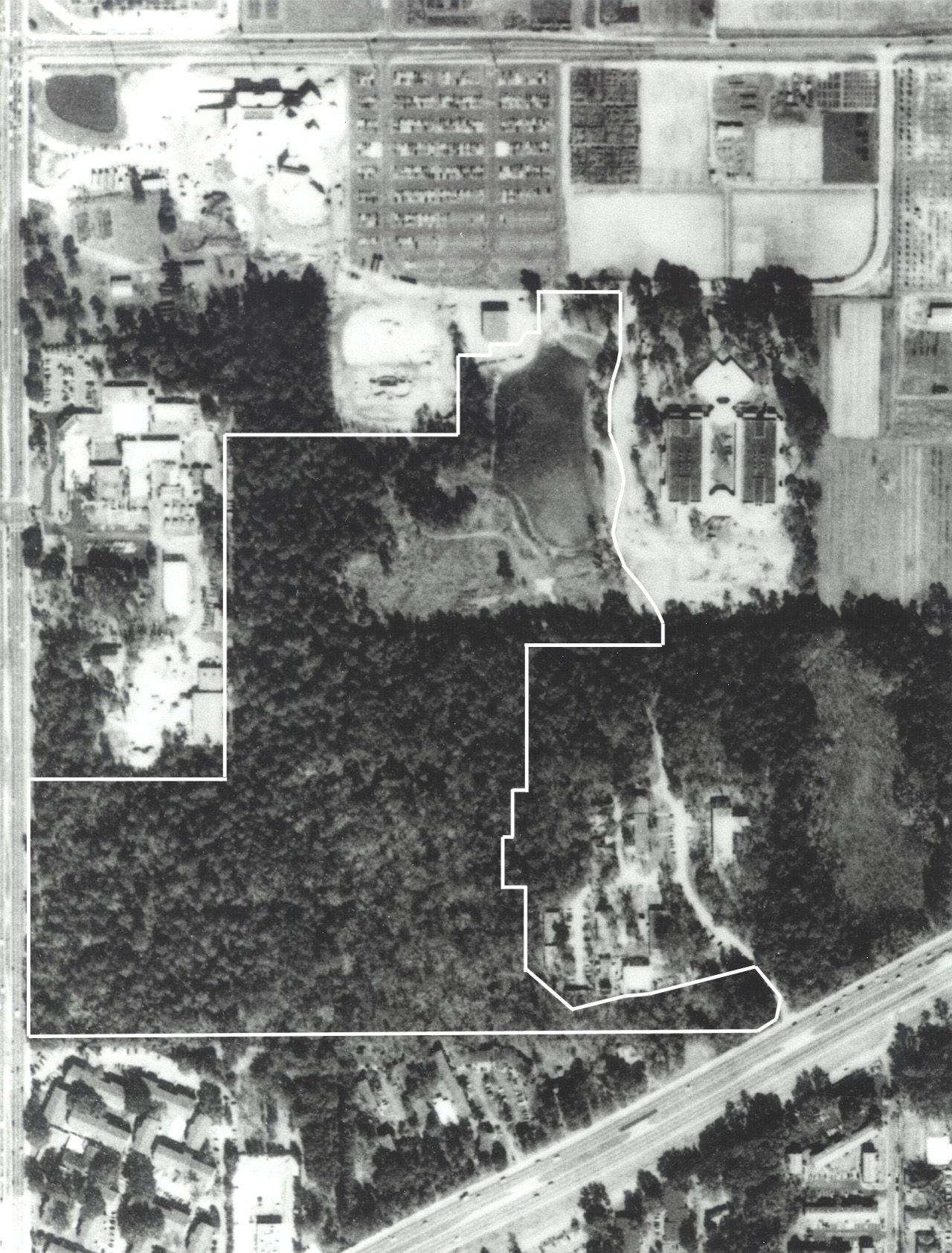 |
In the 1990 photo (left), the Harn Museum, the
Park-and-Ride lot, and the Southwest Chiller Plant have been completed;
the Entomology/Nematology building is almost completed; and the Performing
Arts Center is started. The DPI compound has been enlarged to 15 acres to
accommodate fly-rearing and radiation facilities. The retention pond has
been excavated and will soon be expanded southward to accommodate the
runoff from the Performing Arts Center. |
Notes
(1) Fifield was the Director of the Agricultural Experiment Station. Research was administratively separate from teaching until the formation of IFAS in 1964.
(2) The tract of 192 acres was purchased from CC Richbourg & wife and was approximately the SW quarter of sec 12, R19E T10S.
(3) The materials were interred in concrete vaults and were later shipped out of state.
(4) On an earlier occasion George had told me that the dumped clay had an average depth of 3 or 4 feet.
(5) Garry said that in 1970, they were still using a 1953 Alis Chambers Five bulldozer.
(6) This circular area is apparent on all subsequent photos and is now in NATL grid square H3.
(7) Tung trees are evident at the top edge of the photo, where the Southwest Rec Center is now. Hull Road was a dirt farm road at the time.
(8) The geometric patterns in the fields south of Hull Road in this and later pictures are forage grass plots.
(9) George could not confirm this. A 6-inch PVC water line was later laid from Gasline Trail northward along 34th Street and is now beneath the berm.
(10) For 40 years many small mounds testified to this dumping area a but they were mostly smoothed out when beetle-infested pine trees were cut and removed in the summer of 2001. However a few remain between the Main Trail and the small retention pond north of the mini-storage facility.]
(11) The mound was an enhancement of a natural rise and still exists. It is the hill that East Trail ascends just before it intersects Main Trail from the north.
(12) The lines are forced sewer, abandoned forced sewer, water, and gas.
(13) Until 2001, one row of slash pines still existed just north of the line connecting grid points G4 and H4.
(14) This area is now immediately behind Performing Arts and until 2000 had elephant grass (from Agronomy debris) and lots of weedy trees (as befits a recently sterile area).