
Map archive for Pines in NATL
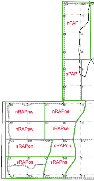 |
Original Diameter Maps As maps are updated to account for tree and snag mortality, the original maps are retired to this archive. To download the 2008 diameter map for any of the ten tracts of restored upland pine, click on the tract of interest (outlined in green and labeled in red) in the map at left. Current maps no longer subdivide C, D, and E for mapping purposes. Original P-number Maps "P numbers" provide a unique identifier for each pine tree and facilitate access to other data for all pines that are part of the Pines layer of the NATL GIS map. To download the 2008 P-number map for a tract of interest, select the appropriate link below. North public area pine (nPAP) South public area pine (sPAP) North restricted area pine, northwest (nRAPnw) North restricted area pine, northeast (nRAPne) North restricted area pine, southwest (nRAPsw) North restricted area pine, southeast (nRAPse) South restricted area pine, old, north (sRAPon) South restricted area pine, old, south (sRAPos) South restricted area pine, new, north (sRAPnn) South restricted area pine, new, south (sRAPns) Subsequent Diameter Maps Block A (=nPAP) (2013) Block B (=sPAP) (2013) Block C (=nRAPnw, nRAPne, nRAPsw, nRAPse) (2013) Block D (=sRAPon, sRAPos) (2013) Block E (=sRAPnn, sRAPns) (2013) |