![]()
![]()
![]()
![]()
![]()
![]()
AutoCAD maps
An AutoCAD map of NATL, prepared by Tim Whitaker of the UF Student Geomatics Association, can be downloaded in two formats: NATL.dwf and NATL.dwg. NATL.dwf is viewable directly on some browsers, such as Internet Explorer 5.0. Once the map is displayed in your browser, right-click on it for a menu of options. For example, you can zoom in and out and turn layers on and off. Both formats can be viewed on a variety of programs available free on the Internet (for example, Volo View Express).
An AutoCAD topographic map of the Stormwater Ecological Enhancement Project, prepared by Chris Sloan of the UF Student Geomatics Association, can be downloaded in two formats [see above]: SEEP.dwf and SEEP.dwg.
Other maps
Click on a thumbnail to display a larger version of the same image.
 |
NATL land use map This, the current land use map for NATL, is similar to the one envisioned in the original proposal for a "Campus Natural Area and Outdoor Teaching Laboratory" (1993). The principal differences are that the public-area upland pine was expanded at the expense of the successional plots, and what was once a retention pond is now an "ecologically engineered wetlands" (SEEP). |
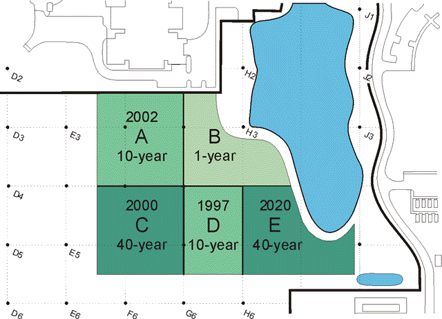 |
Successional plots The land designated to permanently display varied stages of old-field succession is divided into five plots. Plots A and D are to be tilled every 10 years and plots C and E, every 40 years. Plot B is tilled each year in which no other plot is tilled. Plots of the same rotation period are staggered in their starting dates--for example, by 5 years in the case of the 10-year plots. |
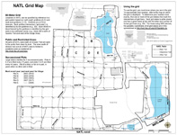 |
GIS-based NATL Grid Map This map is based on eight layers of NATL's GIS map. To this has been added relevent explanatory material, including a description of NATL's 50-meter grid and how it may be used to specify the location of any feature or item in NATL. You can download the PDF file of the current all-NATL grid map by clicking on its thumbnail at left. |
 |
NATL-west Grid Map This GIS-based map has only the NATL-west portion of the all-NATL grid map and includes the same explanatory material. You can download its PDF file by clicking on the thumbnail at left. |
 |
NATL-east Grid Map This GIS-based map shows NATL-east's trails, water features, and 50-meter grid. Because NATL-east is only 11 acres, the scale of its grid map is much greater than that of the 49-acre NATL-west. You can download the PDF file of the NATL-east grid map by clicking on its thumbnail at left. |
 |
Maps of pre-1994 pines This series of maps is from a GIS layer that stores the species, DBH, position, and other noteworthy data for pines judged to have been present when NATL began in 1994. For more about these maps or to download those that are of interest, go to Maps of NATL's Pines. |
 |
Botany Department's permanent plots (1997-date) In 1997, Botany Professor Francis E. "Jack" Putz set up six, 20 x 20 meter, permanent plots in forested portions of NATL and made the initial identifications, counts, and measurements of the trees within each. The results of this and subsequent censuses of these plots are recorded in an Excel spreadsheet. |
 |
NATL-west Grid Map (2007) The Student Geomatics Association first surveyed the grid in 1995-96. Three years later they resurveyed it and drove metal rods into the ground to permanently mark the gridline intersections. In 2006-07 SGA updated the old grid and surveyed new gridpoints in three acres added to NATL-west in 2005. |
 |
Soils map (2000) This map is from a preliminary report on NATL's soils by Mary Collins, Soil and Water Science Department. |
 |
NAAC conceptual plan for public area (2000) The Natural Area Advisory Committee (NAAC) prepared this conceptual plan for NATL's public area as their contribution to the development of the master plan for the Cultural Plaza. |
 |
Cultural Plaza master plan (2001) The Cultural Plaza master plan includes two entrances into NATL. One is via Natural Area Park, which will be reached from the Cultural Plaza by a new pedestrian way. The other is from the Florida Museum of Natural History and envisions that deliveries to Powell Hall will be from SW 34th Street, to allow the current delivery road on the southern edge of the Cultural Plaza to be cut by the entryway. |
 |
Preservation areas P1 and P2 (2004) The yellow lines on this map show the boundaries of preservations areas P1 and P2 as defined in the 2000 update of the UF Master Plan. P1 is entirely within NATL, but NATL includes, in addition, SEEP and Natural Area Park. P2 is 12.3 acres east of Natural Area/Surge Area Drive that includes a large wetland. Two recently constructed buildings are within, or largely within, what was P2 in 2000. [Map prepared by Facilities Planning and Construction, May 2004.] |
 |
NATL-west and NATL-east (2005) In the spring of 2005, the UF administration approved the proposal that Surge Wetland (formerly P2 and now reduced to 10.9 acres) be added to NATL as NATL-east. The original NATL, now NATL-west, is scheduled to be enlarged to 48.8 acres through the inclusion of some of the former Surge Area, thereby increasing NATL's total area from 46 to 60 acres. |
 |
Cultural Plaza master plan (2005) This update of the 2001 Cultural Plaza master plan (see above) retains the new pedestrian way connecting the core of the Cultural Plaza with NATL. However, the assembly area for groups using this entrance into NATL is no longer a gazebo within NATL but instead is an open-air, roofed portion of a southward extension of Powell Hall. |
 |
New grid map for NATL-west (2005) [460 KB] This map is an update of one used from 1996 to 2004 (see above) and incorporates two important changes made during the update of UF's Campus Master Plan. Firstly, NATL now includes 12 acres east of Natural Area Drive ("NATL-east") so this is a grid map only for "NATL-west." Secondly, in addition to NATL-east, about 2 acres of what was formerly the western portion of the Surge Area were added to NATL. |
 |
2000 Old Field Plot C (lower left of group of four old-field plots immediately south of the Phillips Center) was started on its first 40-year rotation by double disking on 28 Nov 2000. |
 |
2006 Old Field Plot B (upper right of group of four plots immediately south of the Phillips Center) was mowed and disked on 6 Nov 2006. |
The three black-and-white aerial photographs below show the area that now encompasses NATL. On each photo, the present boundaries of NATL-west and NATL-east are outlined in blue. Archer Road cuts diagonally across the lower right corner.
 |
11 Feb 1949 This picture was taken soon after UF acquired the land. Hammock occupies the southeastern portion of what will become NATL-west. The rest of that area has no large-crowned trees but numerous longleaf pines of modest size with an understory of scrubby turkey oaks. |
 |
4 Feb 1974 By 1974, the Florida Department of Agriculture had acquired 10 acres on SW 34th Street and built most of its Division of Plant Industry complex, including the Doyle Conner Building. Much of what is to become old-field successional plots has been used to dump clay excavated from sites of Medical Center buildings, and the development of the Surge Area (betweein NATL-w and NATL-e) has begun. |
 |
1 Jan 1990 By 1990, laurel oaks form a continuous canopy in the undisturbed (and unburned) upland pine areas, shading out the turkey oaks and curtailing reproduction of longleaf pines. Immediately north of the future NATL, the Performing Arts Center is under construction and the Entomology and Nematology Building is nearly complete. The DPI complex has expanded onto 5 acres to the south of its original 10 acres. |
Each of the black-and-white aerial photographs below shows an area with Hull Road at the top (= North) and SW 34th Street on the left. Archer Road cuts diagonally across the lower right corner. Except in the 1937 photo, a white outline shows the area of the original NATL-west.
 |
20 Dec 1937 This, the earliest aerial photograph of NATL, is in poor focus but trees with large crowns are evident in the areas that are now upland pine and old fields. These trees are not evident in the 1949 photograph, which agrees with a conclusion in a 2005 study of the ages of NATL's longleaf pines--namely that in about 1940 the longleaf pines of marketable size were harvested from the area that would become NATL. |
 |
11 Feb 1949 This picture was taken soon after UF acquired the land. As in the 1937 picture, hammock occupies the southeastern portion of what will become NATL-west. The rest of the area has no large-crowned trees but numerous longleaf pines of modest size with an understory of scrubby turkey oaks. |
 |
11 Feb 1961 By 1961, the University had begun to use the northeastern part of the future NATL as a place to spread clay excavated from construction sites. To the southeast, the University had begun to develop the Surge Area, where economical buildings that housed research projects could overflow (“surge”) from the main campus. |
 |
4 Feb 1974 By 1974, the Florida Department of Agriculture had acquired 10 acres on SW 34th Street and built most of its Division of Plant Industry complex, including the Doyle Conner Building. |
 |
1 Jan 1990 By 1990, laurel oaks formed a continuous canopy in the undisturbed (and unburned) pineland, shading out the turkey oaks and curtailing reproduction of longleaf pines. The Performing Arts Center was under construction just north of the future NATL, and, to the east, the Entomology and Nematology Building was nearly complete. The DPI complex had expanded onto 5 acres to the south of its original 10 acres. |
Note: An interview about the post-WWII history of NATL's site has a larger set of early aerial photographs explained in greater detail.