![]()
![]()
![]()
![]()
![]()
Topics
Overview
Development
Photosigns
QR trail
Kiosk content
SEEP panels
Trail guide history and archive
Trail sequences
Fliers and slide for publicizing trails
Kiosk plans
Overview
This map of the northern half of NATL-west shows NATL's four self-guided nature trails: Upland Pine, Old-Field, Hammock, and SEEP. The red dotted lines are routes between trail heads and between the Cultural Plaza and trail heads. Kiosks are positioned at entry points to the trails. Each kiosk has a 4x3 ft panel with information appropriate to that portion of the trail system.

The public and university community are encouraged to explore the four distinct habitat types accessed by NATL's nature trails. Three of the trails feature NATL's upland ecosystems: Upland Pine, Old-Field Succession, and Hammock. The fourth trail features the Stormwater Ecological Enhancement Project [SEEP] and has a 500ft elevated boardwalk across this ecologically engineered stormwater retention basin. Each upland trail is approximately one-quarter of a mile and takes 5-15 minutes to walk--a good lunchtime break. The SEEP trail loop is about half a mile. There are picnic tables in Natural Area Park and all trails are easily accessible from there or from the Cultural Plaza with its museums and Camellia Court Café.
The pictures, text, and links below provide detailed information about the nature trails and their kiosks and ecosystems.
Welcome kiosk |
Trail users coming from the Cultural Plaza encounter an introductory kiosk with a display that explains the Natural Area Teaching Laboratory (NATL) and its system of self-guided nature trails. To learn more about NATL go to the menu of photo galleries. |
 |
The display at the start of the Upland Pine Trail explains that longleaf pine woodlands were once prevalent throughout the Southeast and describes how their perpetuation depends on frequent, low-intensity fires.
To learn more about upland pine ecosystems, go to the upland pine photo gallery. Sample academic trail guide. Sample trail sequence. Trail guide archive. |
 |
The display at the start of the Old Field Trail describes the expected sequence of biotic communities that occur when farm fields are abandoned in north Florida. If fire is excluded, the ultimate community will be hammock. To learn more about old-field ecosystems, go to the old-field succession photo gallery. Sample trail guides: basic, advanced. [Trail guide archive.] |
 |
The display at the start of the Hammock Nature Trail explains that the broadleaved forests of north Florida are diverse and dynamic--partly because of frequent natural disturbances. To learn more about hammock ecosystems, go to the hammock photo gallery. Sample trail guides: basic, advanced. [Trail guide archive.] |
 |
The display in the kiosk at the north entry to the SEEP Trail describes the biodiversity of SEEP. It is supplemented by the overview of SEEP that is the southwest panel of the large kiosk in Natural Area Park. Sample basic trail guide. |
 |
The display in the kiosk at the west entry to the SEEP Trail compares the diversity of wetland habitats in the retention basin before and after its ecological enhancement. To learm more about SEEP, go to the wetlands photo gallery. |
 |
On 3 Nov 2008, in Natural Area Park, to honor the completion of NATL's four nature trails, Student Body President Kevin Reilly and UF President Bernie Machen cut a vine-entwined ribbon stretched across the entrance to the SEEP Nature Trail and its boardwalk. Approximately 55 persons attended (photo). |
Funding: The original proposal (1993) to establish NATL envisioned a system of nature trails through the three upland ecosystems in the public portion of NATL. For more than a decade, no nature trails were established because of a lack of funds and the need to tend to more pressing aspects of NATL's development. In 2005, Student Government and the Administration agreed to use $500,000 from the student-generated Capital Improvement Trust Fund for an Environmental Stewardship project to improve the University's 20-odd conservation areas. The Natural Area Advisory Committee [NAAC] asked for money from this project to establish four self-guided nature trails in the NATL-west Conservation Area--namely, the three long-desired upland trails plus a wetlands trail for SEEP, a stormwater retention basin re-contoured in 1998. In the spring of 2006 NAAC was awarded $100,000 for these trails with the understanding that the SEEP Trail would include a boardwalk. When it became apparent that the cost of the boardwalk and six contractor-built, trail-head kiosks would greatly exceed the amount awarded, additional funds were sought and received from several sources. Furthermore, the Florida Museum of Natural History agreed to help build the kiosks, with NAAC-supplied materials, saving NAAC about $6,000. Detailed plans facilitated the Museum's participation.
Trail layout: It was anticipated that a majority of those using the trails would be visitors to UF's Cultural Plaza and that the Florida Museum of Natural History's Outdoor Nature Programs would use NATL much more than in the past. Consequently the layout of the trails was optimized for access to the trail-heads from the Cultural Plaza and from the adjacent Natural Area Park. The last link in completing the trail layout was an access trail from the Cultural Plaza to the trailheads for the Upland Pine and Old Field Nature Trails. This trail was developed by UF's Physical Plant in cooperation with the Cultural Plaza Advisory Committee. The Natural Area Advisory Committee designed and funded the access trail's wayfinding signs, including a directional sign at the origin of the trail and a 3x2 ft sign highlighting the ecosystems traversed by the four nature trails--installed just north of where the trail crosses the Florida Museum of Natural History's service drive. Installation of these signs was completed in March 2010.
Initial content development: Six graduate students in Susan Jacobson's Fall 2006 class on Environmental Interpretation undertook the development of the explanatory panels for the six nature trail kiosks, for the stand-alone panels along the SEEP Nature Trail, and for the west side of the Natural Area Park kiosk. One trio (Josiah Townsend, Krystal Noiseux, Jeffrey Anderson) worked on the panels for the three upland trails, and the other (Kristine Hoffmann, Fred Fisher, Dara Wald) attended to the panels for the NAP and SEEP kiosks and for the signs along the SEEP Trail. To continue their design work during the Spring Semester of 2007, the two trios applied for and received $500 minigrants.
Personnel: Mark Clark, Advisor to the Wetlands Club, was in charge of the development of the SEEP Trail, and T. J. Walker, NAAC Administrative Assistant, saw to the development of the three upland trails. They were greatly assisted by NATL's Graduate Teaching Assistants Kevin Ratkus, Julian Resasco, and Jason Martin, by Undergraduate Assistants Tim Ruscello and Marissa Streifel, by members of the Wetlands Club, and by others who generously volunteered their time and talents.
In 2009, Natalie Hooton developed signs that have color photographs and text to help users of NATL's nature trails identify vascular plants. These are laser printed on DURACopy® waterproof laser paper and glued to 3/32" sheet PVC with 3M Super 77® adhesive. Most of the signs are 5x4 inches (WxH) and are displayed along the nature trails on galvanized sign holders with 18-inch stakes [Gempler's Item No. G49600]. Click here for details of composing the 5x4 signs in PowerPoint.
A spreadsheet lists all NATL photosigns by the scientific and common names of the subject species and gives each sign's size, content, places of display, and other information. Each of the more than 110 signs can be viewed from NATL's Vascular Plant page via links in its master list of species.
The editable files of most photosigns are in PowerPoint. Those for the 35 photosigns that will soon be made into more permanent signs are here: (original draft) (current draft tw).
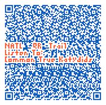
NATL QR Trail: Songs of Crickets and Katydids
Follow @UFNATL or Like us on Facebook
Station 1: A New Kind of Trail
Thank you for visiting the QR (Quick Response) Trail. If you did not have a QR Reader you can still enjoy the trail.
Each station is represented below and has the sound you would have heard if you were scanning the QR code (like the one pictured here) on the trail.
Station 2: Most Complex Song
Most insect songs become repetitious quickly, but a group known as "virtuoso katydids" (e.g., Amblycorypha longinicta) have songs that last for many seconds before they repeat.
Listen to this song
Station 3: Raucous Woodland Chorus
The songs of Common True Katydids (Pterophylla camellifolia) are hard to ignore when many males call at once during summer nights in north Florida woodlands. Like other singing insects they call to attract the nearly mute females.
Listen to this song
Station 4: Trilling Field Cricket
Experts have difficulty identifying specimens of the locally common black field crickets, but even a child can recognize them by their songs. The Southeastern Field Cricket (Gryllus rubens) produces a near-continuous sound (a “trill”).
Listen to this song
Station 5: Chirping Field Cricket
Experts have difficulty identifying specimens of the locally species of common black field crickets, but even a child can recognize them by their songs. The Sand Field Cricket (Gryllus firmus) is the one that produces a series of discrete chirps.
Listen to this song
Station 6: Insect Amplifiers
Mole crickets, like moles, are specialized for burrowing and spend nearly all their time underground. Before males of the Southern Mole Cricket (Scapteriscus borellii) call, they construct a special burrow that amplifies their song and projects it upward--where females may be flying.
Listen to this song
Last Station: Keep on Learning
For more information: Visit our species pages where you will find song samples of longer duration and greater variety than are offered here. You will also find distribution maps, multiple images (in color and black-and-white), references, and more.
Help us make better trails by answering a few quick questions.
NEW QR Signs around NATL
Northern Cardinal A common bird in NATL (and possibly your neighborhood), you can see and hear Northern Cardinals (Cardinalis cardinalis) in many locations. Listen to this song
Northern Bobwhite We have released the Northern Bobwhite (Colinus virginianus) in NATL. Be on the lookout (and listen) for them! Listen to this song
Little Blue Heron If you look around the water’s edge, you may see a Little Blue Heron (Egretta caerulea) hunting for a meal. Listen to this song
These Florida bird songs and more are available at the Florida Museum of Natural History Website.
Be on the lookout for other QR enhanced signs in NATL, you never know where one will show up!
Kiosk content
These links give access to the PowerPoint files for the expanatory panels of the six nature trail kiosks:
Introductory kiosk
Upland Pine Trail kiosk
Old Field Trail kiosk
Hammock Trail kiosk
SEEP Trail kiosk, north entry point
SEEP Trail kiosk, west entry point
Interpretive panels along SEEP trail
Donors
Wetland Ecotone
Stormwater Inlet
Treatment Forebay
Hydrologic Control Structure
Cypress Swamp
Berm Vegetation
Cattail Marsh
Ephemeral Wetland and Sink Hole
Shallow Treatment Marsh and
Compacted Soil
Water Flow in the Basin
Wildlife
Alligator Warning
Algal Blooms
Self-Organizing System
Trail guide history and archive
As each of the three upland nature trails was developed, T. J. Walker prepared a three-page advanced trail guide for it and stocked copies of the appropriate guide in a document box attached to each trailhead kiosk. Each guide described what maight be learned along its trail at 25 points-of-interest marked with numbered stakes. Changes in what was conspicuous and/or interesting along each trail were accommodated by monthly or bimonthly changes in the content of the trail guides and in the positions of the stakes along the trail. In the table below are links to the MSword files of most of these advanced trail guides.
| Upland Pine | Old-Field | Hammock | |
| 2006 | September, October, November, December, |
November, December | |
| 2007 | January, February, March, April, May, June, July, August, September, October, November, December | January, February, March, April, May, June, July, August, September, October, November, December | March, April, May, June, July, August, September, October, November, December |
| 2008 | January, February, March, April, May, June, July, September, October, December | January, February, March, April, May, June, July, September, October, December | January, February, March, April, May, June, July, September, October, December |
| 2009 | February, April | February, April | February, April |
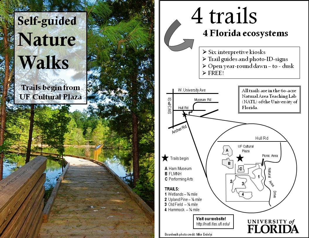 |
In October 2008, NATL TA Erica Van Etten devised a 5x8-inch flier for advertising NATL's nature trails. The front of the flier is printed in color and the backside is in black and white. Fliers are currently kept available to the public at the Florida Museum of Natural History, the Harn Museum, and the Hilton University of Florida Conference Center. [Both sides of the flier are shown in the thumbnail at left, which can be enlarged by clicking on it.] |
 |
This image was created to be part of a two-minute slice show that runs on a screen above the information desk at FLMNH's Powell Hall. |
Kiosk plans and construction
To faciltate construction, the kiosks were designed to consist of three modules: a frame, a roof, and an insert. For three of the kiosks, the roof module was contructed remotely and hoisted intact onto the already erected frame. This proved difficult, so the roofs of the final three were constructed on the erected frame. Detailed instructions for building the modules are included with these plans.
Follow @UFNATL
or Like us on Facebook