| UF Academic Use | Public Use | Family Fun and K-12 Education |

Photographic Record of NATL Vegetation
Four clickable maps facilitate finding photographs you may wish to view. Three of these are for NATL-west, as indicated by the colors on its map, and one is for NATL-east. To go to any of the four, click on the area of interest on the appropriate map.
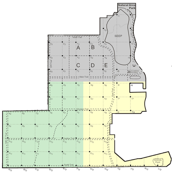
NATL-west
NATL-east
Why photographs are made and preserved
The Natural Area Teaching Laboratory was conceived as a permanent facility "dedicated to teaching students and the public about ecology and biodiversity." To further this mission, two early priorities of the Natural Area Advisory Committee, were to establish a grid system to make it easy to pinpoint the location of any object in NATL and to periodically record NATL's vegetation. The grid system was completed in January 1996, and in January 1997, photographs were made to the north, east, south, and west at 50-meter intervals throughout NATL. In 2007, the process was repeated but in a slightly enlarged NATL-west and with a digital camera. An initial photographic record of NATL-east is planned for 2008, after a 50-meter grid is established there.
NATL's 50-meter grid
Locations in NATL can be specified by reference to a grid system based on north-south gridlines (A to L) and east-west gridlines (1 to 12). Gridlines of each type are 50 meters apart. Each grid intersection is identified by the two gridlines that establish it (e.g., E5 or K12). Each 50x50 meter block established by the gridlines is identified by the grid point in its northwest corner. The Student Geomatics Association first surveyed the grid and put grid stakes in place in the winter of 1995-96. In the spring of 2000, they resurveyed the grid and put metal rods in the ground at the grid points. At that time, they moved the entire grid 1 ft to the east, because the original D gridline was too close to the DPI fence for their operations.
How the 1997 photographs were made and archived
In the fall of 1996, Max Nickerson, Chairman of the Department of Interpretation of the Florida Museum of Natural History, hired professional photographer Michael Turco to record how NATL looked at the beginnings of its planned development as an outdoor teaching laboratory. Between 13 and 27 January 1997, Turco took photographs in the four cardinal directions at each stake in NATL's 50-meter grid. At each stake he positioned his camera (on its tripod) 6 ft above ground level and, with 11 exceptions, 1 ft north of the stake. The exceptions were A8, 1ft south of stake; B8, 1 ft south of stake; D3, D4, D5, D6, D7, 1 ft east; D11, D12, 1 ft west; E5, 1 ft south; F11, 1 ft east. Photographs were taken N, S, E, and W except where the stakes were on the NATL boundary--along the fence at the Division of Plant Industry compound and near Natural Area Drive east of SEEP.
The 297 color slides resulting from this project were deposited in the Florida Museum of Natural History's photographic archive in Powell Hall. In March 2004, 293 of the 297 slides were scanned into jpg files of 4202 x 2869 pixels and down-sampled to 640 x 425 pixels for posting on NATL's web site. The files were named to indicate grid stake, direction, year, and resolution. For example, the high and low resolution files of the eastward view from grid stake G8 are G8e97j.jpg [j for jumbo] and G8e97.jpg. All files were saved to CDs which are kept with the archived slides in Powell Hall. Unfortunately, all but 10 of the 293 scans were done in a way that made them mirror images of the actual views. The ten slides that were done correctly were I5n, I5e, I5s, I5w, I12n, I12e, I12s, I12w, J1n, and J1s. The four slides that could not be located for the intial scanning were D12w, E4e, F5e, and F9s. These were found a year later, scanned correctly, and returned to Powell Hall along with a CD of the scans. All 297 of the slides made in 1997 have been scanned (293+4) and the resulting files saved to CDs that are in Powell Hall. However, 283 (297-14) of the scans must be flipped horizontally to give correct views of the images on the slides. The mistakes in scanning the 1997 images were discovered early in 2007 and the 283 incorrect images posted on this web site in 2004 were replaced with corrected ones in June 2007.
On 1 April 2004, to add to the record of vegetation for two key grid stakes, photos in the four cardinal directions were taken at E4 and G4 and added to the posted record.
How the 2007-08 photographs were made and archived
In February 2007, T. J. Walker took photographs of NATL's vegetation from each of the stakes that delineate the 50-meter grid of NATL-west. In most respects, this was a repeat of what Michael Turco did in January 1997 (see above). However, the 50-meter grid was old and NATL had grown by 14 acres. This necessitated three preparatory steps.
(1) Verify previously established gridpoints.
In the spring of 2000, the Student Geomatics Association had re-surveyed NATL's original 50-meter grid and, to permanently mark the points, had driven a half-inch-dia metal rod flush to the ground surface at each gridpoint. Subsequently, if any of the white, 1-inch-dia, PVC grid stakes that marked the gridpoints were moved, the movement could be detected and the iron rod could be found and used to restore the stake to its correct position.
In the fall of 2005, all gridpoint stakes were checked for the iron rods that would verify their being correctly placed. Surprisingly, these 19 grid stakes had no rod: A10, A12, C11, C12, D7, E6, E10, F4, F5, F6, F7, F8, F10, G6, G7, G8, H6, I5, J4. In addition these four gridpoints could not be checked because the stakes were missing: B9, C10, G3, L12.
Note: The Student Geomatics Association did not complete the initial survey of the grid in NATL-east in time for photographs to be taken in 2007, which necessitated postponing photography there until 2008.
(2) Re-establish "lost" gridpoints and establish new ones.
In September 2005, the Student Geomatics Association [SGA] was asked to provide volunteers to do the surveying required to re-establish old NATL gridpoints and to establish new ones. Specifically, 23 gridpoints in NATL-west needed to be re-surveyed; 6 new gridpoints needed to be established in the new part of NATL-west; and the grid needed to be extended into NATL-east (approximately 10 new gridpoints). In October an SGA member volunteered for the job, was shown the tasks, and accepted the responsibility. In January 2006, after failing to start during the Fall Semester, the member once more promised to do the needed surveying. In February the member stopped responding to emails, and in March the GSA advisor was asked to help. He produced a new volunteer, Kelly R. Garner, who managed, by the end of January 2007, to relocate and mark with iron pins the 19 lost gridpoints and to survey 5 of the 6 new gridpoints needed in NATL-west.
(3) Clear the gridlines
In 1997, the gridlines had been recently cleared to permit the establishment of the gridpoints. This made it easy to move from gridpoint to gridpoint, to sight along the gridlines when the photographs were taken, and for the camera to record a larger sample of the vegetation. A southern pine beetle outbreak in 2001 had necessitated commercial removal of numerous loblolly pines from the public-area hammock ecosystem. In 2004, two hurricanes brought down mature trees throughout NATL, but especially in the hammock ecosystem. These disturbances opened up the canopy and contributed to the gridlines becoming choked with vine-covered undergrowth and blocked by fallen trees. The task of clearing the gridlines began in fall 2005 but was not completed until January 2007.
Making the photos
All pictures were made with a Canon EOS 20D single-lens-reflex, 8 megapixel digital camera with a 50mm, auto-focus, Canon lens. The camera was mounted on a SLIK Universal U-210 tripod, which allowed adjusting all aspects of the camera position. With five exceptions (see below), the tripod was positioned so that the camera was directly above the gridpoint or nearly so. Deviations of no more than 1 ft. were allowed to prevent nearby obstacles (usually tree trunks) blocking the view along the gridline. Camera height was adjusted so that the viewfinder eyepiece was at eyelevel (about 5 ft. above the ground). To make sure the camera was still when each picture was taken, the camera's self-timer was used to insert a delay of 10 seconds between the press of the shutter button and the exposure. The lens opening was kept at f/16 by using the aperture-priority, automatic-exposure mode. Auto focusing was set manually to the middle focusing point. This point was used to adjust the angle of elevation of each shot, with the default angle being to aim this point at the top flag on the 9-9.5 ft pole at the next-in-line gridpoint. If there was no gridpoint flag available to determine the azimuth and elevation of the camera, a compass was used for the azimuth (allowing for magnetic declination), and the elevation was subjectively set. For westward pictures along gridline A, the elevation was adjusted to show the vegetation on top of the berm. Image quality was set at "Large Fine," which records an 8.2 million pixel image in a low-compression jpeg file. ISO light-sensitivity value was generally set at 100 or 200 depending on the amount of light.
NATL-west: From 14 Feb to 24 Feb 2007, 315 photos were taken at 81 gridpoints. On 1 Mar 2007. eight photos were taken from the final 2 of the 83 gridpoints. A spreadsheet records the sequence in which the 323 photos were taken, the ISO settings used, when a compass (rather than a grid stake 50 m away) was used to determinge azimuth of the camera, and the eastward deviations from the gridpoint for the photos taken at D3, D4, D5, D6, and D7.
NATL-east: From 6 Feb to 9 Feb 2008, 48 photos were taken at 12 gridpoints. Details are in a spreadsheet.
["January 2008," the date listed for online NATL-east grid pictures is not correct and should be changed to "February 2008" when new photos are added.]