| UF Academic Use | Public Use | Family Fun and K-12 Education |

Maps of NATL-east's Hardwoods
In 2009-10, to enable monitoring of future growth and mortality of NATL-east's mature hardwoods, Robert Guggenheim, supervised by Tom Walker, measured and mapped all hardwoods with a DBH of 30cm or more. Methods are described at the bottom of this page. All pines in NATL-east are loblollies; on the maps of NATL-east hardwoods. Additional information about NATL-east's pines is available at Maps of NATL's Pines and in the Pines layer of NATL's ArcGIS map.
Maps of hardwoods in NATL-east
Aerial photographs going back to 1937 show no disturbance in the wooded portions of NATL-east nor do they refute the notion that the largest loblollies there got their start at the same time as the largest ones in NATL-west. Age determination of selected trees is needed to establish whether a long ago major disturbance started many of NATL's largest loblollies and, if so, the approximate year of the disturbance.
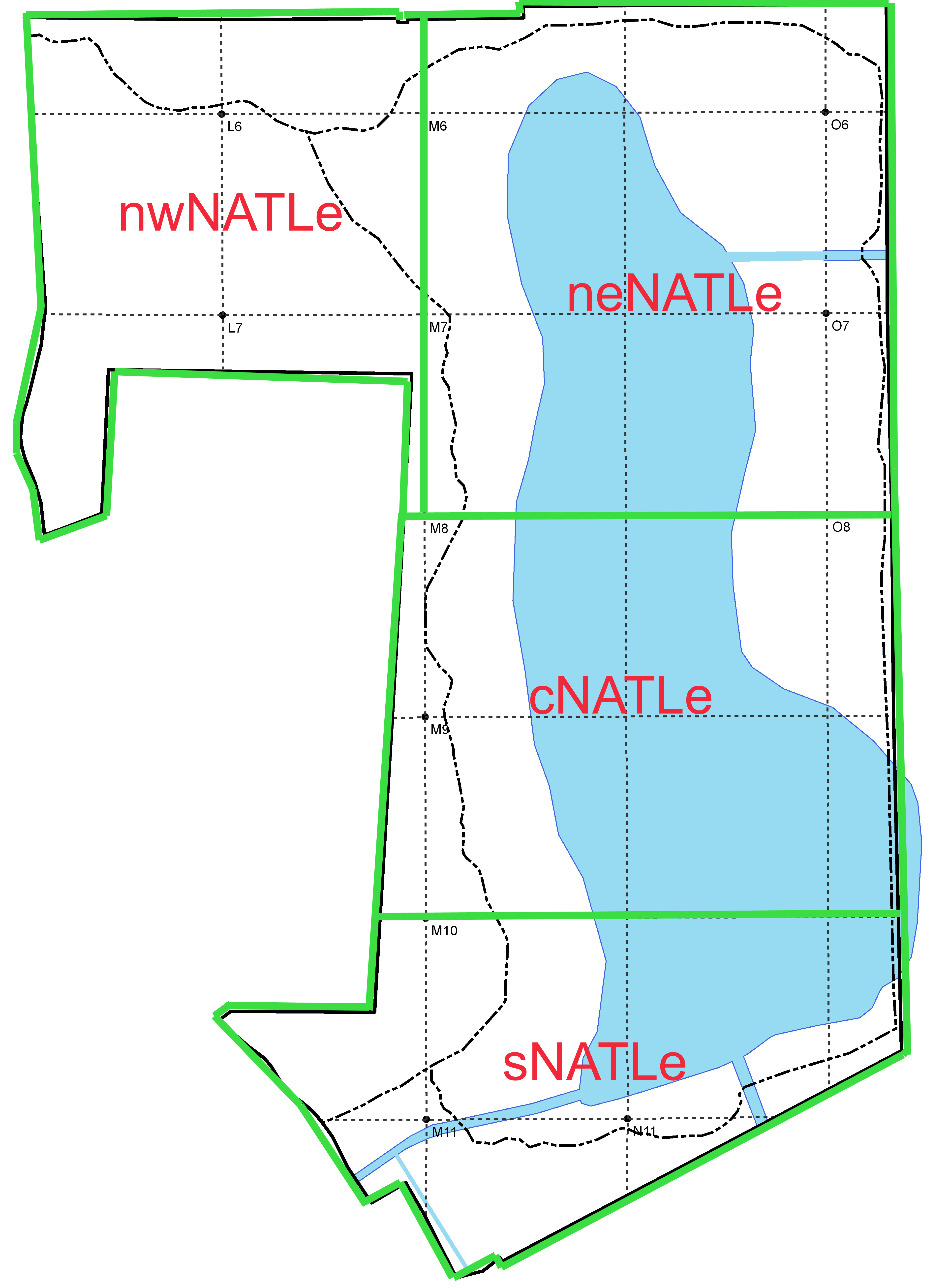 |
Species/Diameter Maps A diameter map of hardwoods shows their species, diameter-breast-high in cm, and location. To download a diameter map for any of the 4 tracts on the map at left, click on the tract of interest (outlined in green and labeled in red). H-number Maps "H numbers" provide a unique identifier for each hardwood tree and facilitate access to other data for all hardwoods that are part of the Hardwoods layer of the NATL GIS map. To download a H-number map for a tract, select the appropriate link below. Northwest NATL-east (pdf) Northeast NATL-east (pdf) Central NATL-east (pdf) South NATL-east (pdf) Excel spreadsheets The spreadsheet GISpines.xls has the same data as the .dbf file of the Hardwoods layer of NATL's ArcGIS map (GIS with hardwoods updated here). This includes a record for each tree, with its H-number, NATL tract and grid square, UTM coordinates, diameter in cm, date of measurement, notes, and changes since 2009. Another spreadsheet, NATLe_Hardwoods.xls, summarizes the hardwood mapping project by tract. |
Earlier, relevant work
In 2003, because a four-lane extension of SW 24th Avenue had been proposed for the south extreme of NATL-west, T. J. Walker and his daughter mapped and measured the 95 trees that were 30cm or more DBH and within the proposed 90-foot right-of-way. Among these trees were six longleaf pines (32 to 61 cm DBH) and 11 loblolly pines (34 to 65 cm DBH). The detailed data from the survey were recorded in a spreadsheet.
In 2005, Jeff Morton wrote the final report for his Minigrant project "Historical ecology of UF's Natural Area Teaching Laboratory." In the report he listed nine longleaf pines and nine loblolly pines that he had cored in order to determine their ages. Seventeen of these trees were matched with those mapped in the current project and an addendum prepared and attached to Morton's final report.
Methods
In 2008, as Jason Martin was developing a ArcGIS map of NATL, he worked with Robert Guggenheim (RG) and T. J. Walker (TW) to develop procedures for making the locations of individual pine trees, and related data, a layer in that map.
The procedures finally adopted had these steps:
- 1. Grid lines were cleared and grid points flagged to make it easier to assign any pine to a single grid block. (A pine on a grid line was assigned to the block that seemed to have the larger share.)
- 2. For each designated tract, RG identified each pine and measured its DBH at approximately 130 cm from the base of the tree at dirt level. If the tree had branched into two or more trunks at breast height, the DBH was taken of each trunk of the tree at DBH, and written as, for example, DBH130=30/12/12.
- 3. RG then estimated the pine's location within its grid block by symbols penciled onto a paper map. He also measured and mapped snags of pines (even when they had fallen), but did not attempt to identify them to species.
- 4. The trees (and snags) were assigned unique identifying "P numbers" (e.g., P122) and their coordinates determined with the Trimble GPS unit.
- 5. The coordinates, P numbers, and DBHs were transferred to the Pines layer of NATL's ArcGIS map and preliminary maps printed. Coordinates were not corrected by reference to a base station.
- 6. With the preliminary DBH maps in hand, TW and RG went to the field to determine if every pine in the tract was mapped and correctly identified. When the GPS position of a pine was in significant conflict with its position as observed in the field (e.g., it was on the wrong side of a grid line or not close to a near neighbor), a more appropriate position was noted on the preliminary map.
- 7. RG used GIS software to reposition the misplaced pines and printed drafts of final maps.
- 8. TW made sure that the final maps incorporated the changes agreed upon in the field.
- 9. TW made sure that the final spreadsheet had each listed pine correctly classified as to region, grid square, and species.
Important details of these procedures were recorded in Instructions for Trimble GeoXT GPS unit & ArcGIS.